Environmental Damage as a Weapon of War? Open Source Industrial Risk Analysis of the Mosul Battle
The start of the operation to retake Mosul from the Islamic State (IS) has seen unprecedented use of environmental pollution as a means to hinder the advancing of troops and as an apocalyptic scorched earth tactic. In June 2016, when Iraqi forces were approaching the city of Qayyara, in Ninewa province, IS set alight dozens of oil wells, and flooded the streets with crude oil. The oil has also polluted the Tigris river, a source of drinking water and lead to an accumulation of health problems.
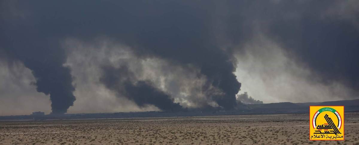
Burning oil wells at Qayyarah. Courtesy of @teamsmediawar
Thousands of civilians and armed forces were exposed to the noxious fumes from the burning oil wells, which have been on fire now for for almost 4 months. Meanwhile, local environment faced severe pollution from the crude oil and the burned oil particles, rendering local agricultural lands useless, and affecting livestock.
NASA’s LANDSAT8 has been instrumental in monitoring smoke plumes as they spread across the Ninewa plains.
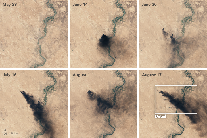
NASA Earth Observatory images by Joshua Stevens, using Landsat data from the U.S. Geological Survey. Caption by Pola Lem. Instrument(s): Landsat 8 – OLI
Preparing a toxic conflict
In September 2016, rumours spread that the Islamic State, anticipating the assault on Mosul, were digging trenches around the city and planning to fill them up with crude oil that when burned would blacken the skies and hinder airstrikes. A few days after the start of the attack on the city, these rumours turned into reality, as huge dark clouds of burning oil spread. North of Mosul, a number of fires were seen on satellite images around towns and villages as result of the ongoing fighting. These images reminded many of the 1991 Gulf War, when retreating Iraqi forces set fire to over 700 Kuwaiti oil wells. The wells burned for months and severely impacted the environment, causing a temporarily drop in temperature and localised health risks
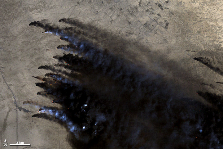
Image courtesy Matt Radcliffe, using Landsat data. Caption by Ellen Gray. February 22, 1991.
Sensor(s): Landsat 5 – TM
In a disturbing turn of events, IS last week set alight stockpiles of sulphur dioxide at the Mishraq Sulphate Factory, leading to large toxic cloud plume spreading over dozens of kilometres. The same factory was also targeted by arsonist in 2003, which resulting in the burning of 300.000-400.000 tons of sulphur, creating a major environmental disaster at the time. The United Nations Environment Program (UNEP) did a risk assessment of the fire:
“Burning of pure sulphur produces sulphur dioxide gas, which is corrosive and toxic. At the high concentrations generated by the fire it was present as an aerosol (white smoke/fumes). When dispersed in the atmosphere it reacts with water, other gases and dusts to form sulphuric acid and sulphates. The sulphuric acid is contained in water vapour and droplets and forms acid rain.”
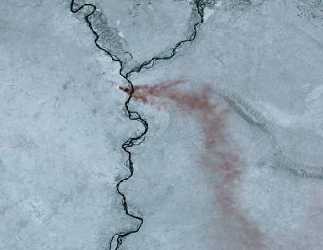
Sulphur dioxide plume from Mishraq spreading over Iraq, 2003. Source: UNEP
Though the UN concluded – some 2 years after the arson – that health and environmental risks were low, the sulphur smoked did affect 25 communities at the time of the fire, leading to localised health problems due to inhalation. The smoke plume also created a local hole in the ozone layer.
Currently, thousands of civilians around the sulphur plant and Qayyarah have been exposed to the toxic oil and sulphur fumes and many of them are reportedly being treated for health problems. Iraqi armed forces and US support troops have been given specialised equipment to protect them against exposure to these noxious plumes.

Imagery from Planet.com, with additional information from AllSource Analysis
Humanitarian concerns over environmental impacts
The relatively new tactic of using industrial toxics as a weapon of war has raised serious concerns among UN agencies, including the UN Office for Coordination of Humanitarian Affairs (OCHA), and the UN Operation Satellite Application program (UNOSAT), which is using real time satellite imagery to monitor the situation. In a situation update on the 19th of October, UNOCHA described the situation:
“People arriving to Al Qayyarah seeking refuge face serious health risks. Burning crude oil produces a wide range of pollutants, including soot and gases. The subsequent effects on local populations’ and the health of affected communities depend on the concentration of the pollutants inhaled, as well as the duration of exposure and proximity to the oil fires. Potential health effects of exposure entail skin irritation; runny nose; cough; shortness of breath; irritation of eyes, nose and throat; as well as aggravation of sinus and asthma conditions. (…)The release of toxic substances from damaged industrial facilities remains a concern, as there are several such plants in the area around Mosul.”
Indeed, there are number of industrial sites in and around Mosul that could pose serial health and environmental risks. The presence of a range of hazardous materials at these sites could be either used as a weapon to hinder the progress of the Iraqi army and Peshmerga forces, or they may be burned and scattered as retreating fighters employ scorched earth tactics, wreaking havoc on local population. Consulted for this article, partners of PAX in these areas described IS’ aims:
“to cause as much damage as possible in order to prevent the government bodies benefiting from those areas. In addition, the militants group think that the flame will prevent plans and satellites from determining their places and their movements as they leave. Furthermore, IS see the local communities as betrayers, and burning the areas before leaving it is also a way of punishment of the local civilian for not supporting them.”
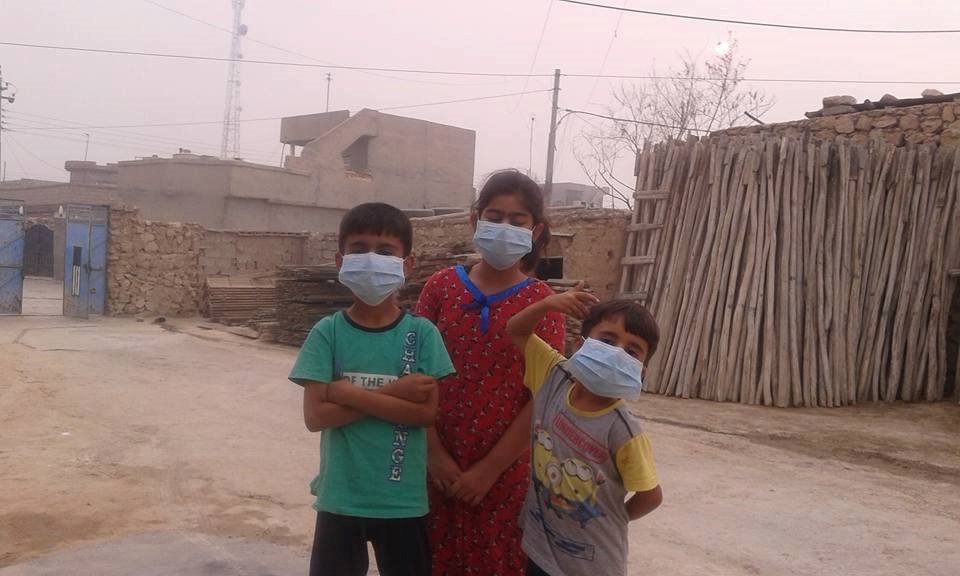
Children in Makhmour, west of Mishraq, wearing protection masks to limit sulphur dioxide inhaltion. October 23, 2016
An open source intelligence overview of industrial risks
As it is likely that IS will use industrial chemicals on a larger scale as a military tactic or punishment to local populations, identifying and locating areas of risk is important for the preparation of potential remediation work. With the use of open source data (Wikimapia, Google Earth, Iraqi Energy Outlook Document) and bearing in mind historic examples of attacks on industrial sites such as Iraqi in 2003, or the Balkans in 1995 and 1999, the following quick and dirty analysis provides some initial examples. Though there are likely numerous other sites not noted, this analysis is an attempt to map these risks.
Oil industry:
- In the centre-south of Mosul, there a huge oil storage site from Northern oil products – Wadi Hajar (and parts of it are already burning)
- Oil storage site at Tal Dhabab (south of Mosul)
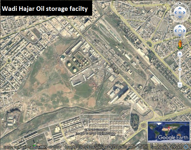
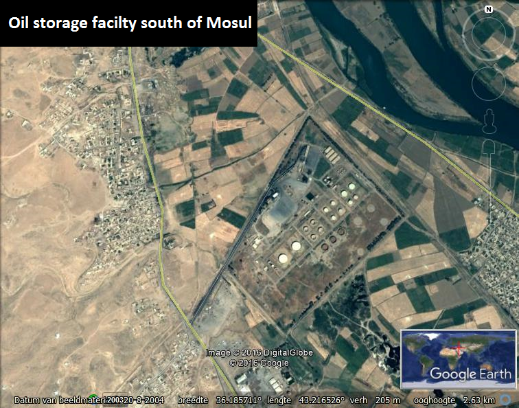
Industrial sites
There are several textile factories that prior to the conflict were already an environmental health risk concern due to presence of large amounts of solvents and other industrial toxics used in production.
- Mosul sugar factory: storage of sulphur dioxide
- Hamam Al Alil Cement factory south of Mosul: hazardous waste products
- Wadi Ekab industrial district, which according to the New York Times is rigged with explosives
- Various large textile factories
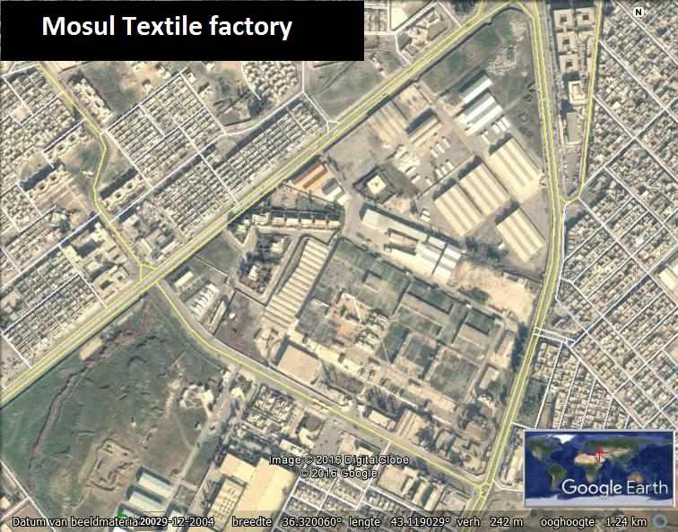
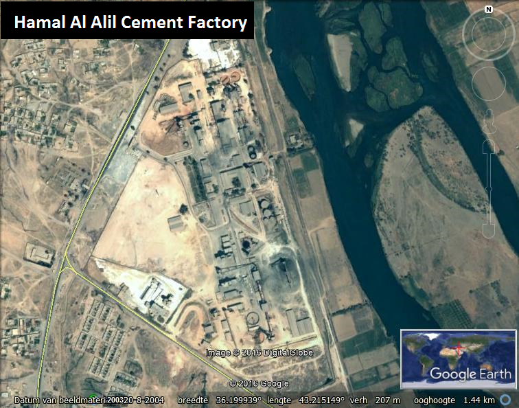
Critical infrastructure
Power plants as well as electricity distribution, water purification and sewage sites often store a range of hazardous materials such as Polychlorinated Biphenyl (PCBs), a persistent organic pollutant and known carcinogenic material, ammonia and other chemical products that are used on site. Or by attacking these sites they can cause indirect health risks, e.g. loss of power to hospital, sewage systems and water purification, which can result in the outbreak of communicable diseases.
- Thermal plants south of Mosul:
- Electric substations throughout the city that store PCBS.
- The power station west of Mosul
- Water treatment plant west of Mosul.
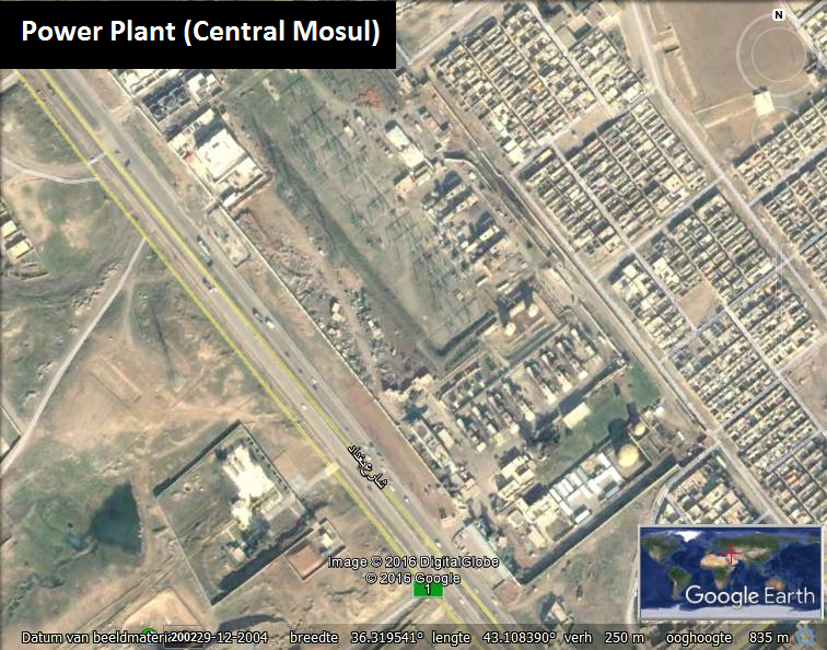
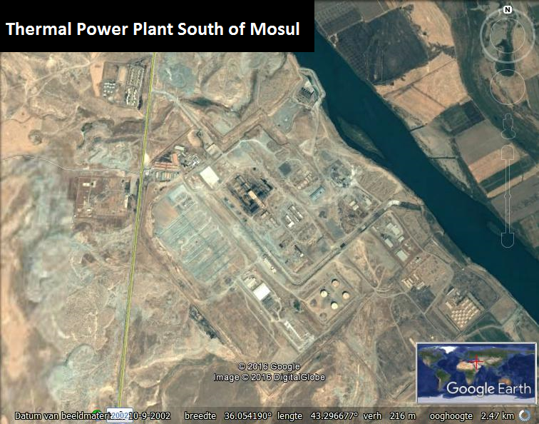
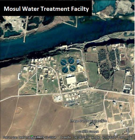
Mosul, being one of the largest Iraqi cities with over a million inhabitants, is a vulnerable target for IS when it’s on the brink of defeat. Using industrial toxics as a means of warfare is a real risk and therefore, timely identification of vulnerable targets and preparing remediation of polluted sites should start soon to limit civilian health risks and prevent a long-term environmental disaster. Based on the standardized Hazard Identification Tools, part of the Flash Environment Assessment Tool, the sites mentioned above can be classified to have the following technological risk to human health and the environment:
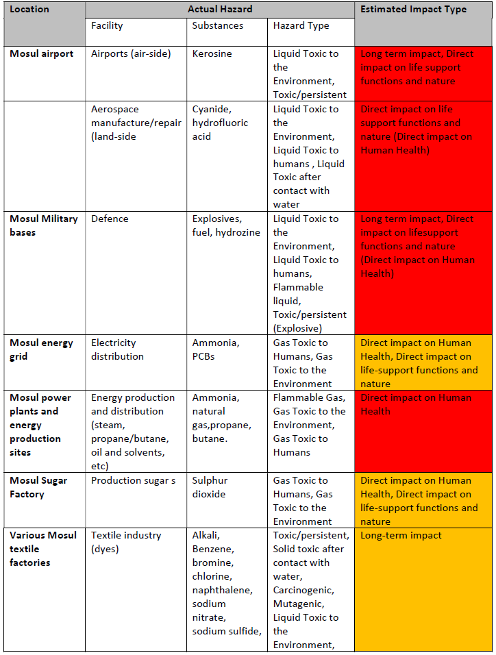
Hazard Identification Tool Mosul
To timely deal with the risks born from damage to industrial sites and other facilities with chemicals presents, various hazard identification tools have been developed to be utilized in environmental emergency responses such as natural disasters. A large body of literature on risk assessment tools and fast responses have been devised for chemical incidents, hazard identification of toxics[PDF] disaster waste management [PDF], and environmental health management [PDF] in humanitarian operations. Naturally, conflict affected States often lack the necessary capacities or expertise – or have prioritized other issues – to handle these complex problems. In other cases, there may not be a state structure left at all.
Direct and long-term health and environmental risks
Using the environment as a weapon of war is a growing concern among UN agencies, environmental experts and civil society. The current battle around Mosul highlights risks in conflict areas where there is industrial toxics that can be employed by armed groups are present, or where natural resources can be used to leave a trail of destruction – serving either tactical purposes or merely out of spite and revenge.
Similar tactics have been used in Libya, while in Syria, continues attacks on oil facilities in Deir ez-Zor by the Russian Air Force and the Operation Inherent Resolve Coalition resulted in widespread destruction of oil sites. As a result, tens-of thousands of civilian operated make-shift oil refineries began to be operated, often involving children.
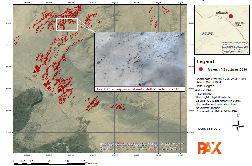
Makeshift oil refineries, 2016, Deir az-Zor, Syria
Open source data collection has been a helpful tool. For example, using NASA LANDSAT8 images provides a good view of the smoke cover of the oil wells burning in and around Qayyarah and the Mishraq sulphur plant. Social media reporting is also instrumental in identifying attacks on critical infrastructure and industrial sites. Yet what is needed is a structured approach that identifies and monitories conflict-related environmental damage, as well as dissemination of this information to relevant humanitarian organizations and local authorities, and subsequent follow-up responses that include the technical expertise and capacity to verify this information on the ground.
Thanks to Planet.com for imagery used in this report.
